Alexander B. Neely, Seulgi Moon, Roman A. DiBiase, Leonard S. Sklar, Marina O. Argueta
{"title":"野火前后输送到易发生泥石流的陡峭河道的沉积物粒度","authors":"Alexander B. Neely, Seulgi Moon, Roman A. DiBiase, Leonard S. Sklar, Marina O. Argueta","doi":"10.1002/esp.5819","DOIUrl":null,"url":null,"abstract":"<p>Debris flows are powered by sediment supplied from steep hillslopes where soils are often patchy and interrupted by bare-bedrock cliffs. The role of patchy soils and cliffs in supplying sediment to channels remains unclear, particularly surrounding wildfire disturbances that heighten debris-flow hazards by increasing sediment supply to channels. Here, we examine how variation in soil cover on hillslopes affects sediment sizes in channels surrounding the 2020 El Dorado wildfire, which burned debris-flow prone slopes in the San Bernardino Mountains, California. We focus on six headwater catchments (<0.1 km<sup>2</sup>) where hillslope sources ranged from a continuous soil mantle to 95% bare-bedrock cliffs. At each site, we measured sediment grain size distributions at the same channel locations before and immediately following the wildfire. We compared results to a mixing model that accounts for three distinct hillslope sediment sources distinguished by local slope thresholds. We find that channel sediment in fully soil-mantled catchments reflects hillslope soils (<i>D</i><sub>50</sub> = 0.1–0.2 cm) both before and after the wildfire. In steeper catchments with cliffs, channel sediment is consistently coarse prior to fire (<i>D</i><sub>50</sub> = 6–32 cm) and reflects bedrock fracture spacing, despite cliffs representing anywhere from 5% to 95% of the sediment source area. Following the fire, channel sediment size reduces most (5- to 20-fold) in catchments where hillslope sources are predominantly soil covered but with patches of cliffs. The abrupt fining of channel sediment is thought to facilitate postfire debris-flow initiation, and our results imply that this effect is greatest where bare-bedrock cliffs are present but not dominant. A patchwork of bare-bedrock cliffs is common in steeplands where hillslopes respond to channel incision by landsliding. We show how local slope thresholds applied to such terrain aid in estimating sediment supply conditions before two destructive debris flows that eventually nucleated in these study catchments in 2022.</p>","PeriodicalId":11408,"journal":{"name":"Earth Surface Processes and Landforms","volume":"49 7","pages":"2110-2133"},"PeriodicalIF":2.7000,"publicationDate":"2024-04-05","publicationTypes":"Journal Article","fieldsOfStudy":null,"isOpenAccess":false,"openAccessPdf":"https://onlinelibrary.wiley.com/doi/epdf/10.1002/esp.5819","citationCount":"0","resultStr":"{\"title\":\"The grain size of sediments delivered to steep debris-flow prone channels prior to and following wildfire\",\"authors\":\"Alexander B. Neely, Seulgi Moon, Roman A. DiBiase, Leonard S. Sklar, Marina O. Argueta\",\"doi\":\"10.1002/esp.5819\",\"DOIUrl\":null,\"url\":null,\"abstract\":\"<p>Debris flows are powered by sediment supplied from steep hillslopes where soils are often patchy and interrupted by bare-bedrock cliffs. The role of patchy soils and cliffs in supplying sediment to channels remains unclear, particularly surrounding wildfire disturbances that heighten debris-flow hazards by increasing sediment supply to channels. Here, we examine how variation in soil cover on hillslopes affects sediment sizes in channels surrounding the 2020 El Dorado wildfire, which burned debris-flow prone slopes in the San Bernardino Mountains, California. We focus on six headwater catchments (<0.1 km<sup>2</sup>) where hillslope sources ranged from a continuous soil mantle to 95% bare-bedrock cliffs. At each site, we measured sediment grain size distributions at the same channel locations before and immediately following the wildfire. We compared results to a mixing model that accounts for three distinct hillslope sediment sources distinguished by local slope thresholds. We find that channel sediment in fully soil-mantled catchments reflects hillslope soils (<i>D</i><sub>50</sub> = 0.1–0.2 cm) both before and after the wildfire. In steeper catchments with cliffs, channel sediment is consistently coarse prior to fire (<i>D</i><sub>50</sub> = 6–32 cm) and reflects bedrock fracture spacing, despite cliffs representing anywhere from 5% to 95% of the sediment source area. Following the fire, channel sediment size reduces most (5- to 20-fold) in catchments where hillslope sources are predominantly soil covered but with patches of cliffs. The abrupt fining of channel sediment is thought to facilitate postfire debris-flow initiation, and our results imply that this effect is greatest where bare-bedrock cliffs are present but not dominant. A patchwork of bare-bedrock cliffs is common in steeplands where hillslopes respond to channel incision by landsliding. We show how local slope thresholds applied to such terrain aid in estimating sediment supply conditions before two destructive debris flows that eventually nucleated in these study catchments in 2022.</p>\",\"PeriodicalId\":11408,\"journal\":{\"name\":\"Earth Surface Processes and Landforms\",\"volume\":\"49 7\",\"pages\":\"2110-2133\"},\"PeriodicalIF\":2.7000,\"publicationDate\":\"2024-04-05\",\"publicationTypes\":\"Journal Article\",\"fieldsOfStudy\":null,\"isOpenAccess\":false,\"openAccessPdf\":\"https://onlinelibrary.wiley.com/doi/epdf/10.1002/esp.5819\",\"citationCount\":\"0\",\"resultStr\":null,\"platform\":\"Semanticscholar\",\"paperid\":null,\"PeriodicalName\":\"Earth Surface Processes and Landforms\",\"FirstCategoryId\":\"89\",\"ListUrlMain\":\"https://onlinelibrary.wiley.com/doi/10.1002/esp.5819\",\"RegionNum\":3,\"RegionCategory\":\"地球科学\",\"ArticlePicture\":[],\"TitleCN\":null,\"AbstractTextCN\":null,\"PMCID\":null,\"EPubDate\":\"\",\"PubModel\":\"\",\"JCR\":\"Q2\",\"JCRName\":\"GEOGRAPHY, PHYSICAL\",\"Score\":null,\"Total\":0}","platform":"Semanticscholar","paperid":null,"PeriodicalName":"Earth Surface Processes and Landforms","FirstCategoryId":"89","ListUrlMain":"https://onlinelibrary.wiley.com/doi/10.1002/esp.5819","RegionNum":3,"RegionCategory":"地球科学","ArticlePicture":[],"TitleCN":null,"AbstractTextCN":null,"PMCID":null,"EPubDate":"","PubModel":"","JCR":"Q2","JCRName":"GEOGRAPHY, PHYSICAL","Score":null,"Total":0}
The grain size of sediments delivered to steep debris-flow prone channels prior to and following wildfire
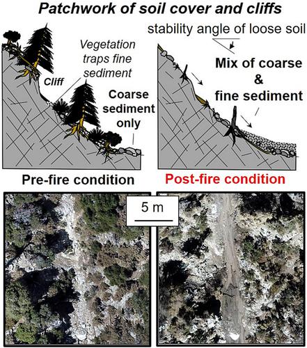
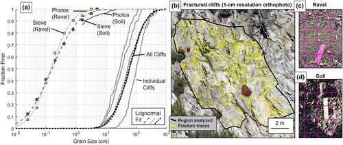
Debris flows are powered by sediment supplied from steep hillslopes where soils are often patchy and interrupted by bare-bedrock cliffs. The role of patchy soils and cliffs in supplying sediment to channels remains unclear, particularly surrounding wildfire disturbances that heighten debris-flow hazards by increasing sediment supply to channels. Here, we examine how variation in soil cover on hillslopes affects sediment sizes in channels surrounding the 2020 El Dorado wildfire, which burned debris-flow prone slopes in the San Bernardino Mountains, California. We focus on six headwater catchments (<0.1 km2) where hillslope sources ranged from a continuous soil mantle to 95% bare-bedrock cliffs. At each site, we measured sediment grain size distributions at the same channel locations before and immediately following the wildfire. We compared results to a mixing model that accounts for three distinct hillslope sediment sources distinguished by local slope thresholds. We find that channel sediment in fully soil-mantled catchments reflects hillslope soils (D50 = 0.1–0.2 cm) both before and after the wildfire. In steeper catchments with cliffs, channel sediment is consistently coarse prior to fire (D50 = 6–32 cm) and reflects bedrock fracture spacing, despite cliffs representing anywhere from 5% to 95% of the sediment source area. Following the fire, channel sediment size reduces most (5- to 20-fold) in catchments where hillslope sources are predominantly soil covered but with patches of cliffs. The abrupt fining of channel sediment is thought to facilitate postfire debris-flow initiation, and our results imply that this effect is greatest where bare-bedrock cliffs are present but not dominant. A patchwork of bare-bedrock cliffs is common in steeplands where hillslopes respond to channel incision by landsliding. We show how local slope thresholds applied to such terrain aid in estimating sediment supply conditions before two destructive debris flows that eventually nucleated in these study catchments in 2022.
期刊介绍:
Earth Surface Processes and Landforms is an interdisciplinary international journal concerned with:
the interactions between surface processes and landforms and landscapes;
that lead to physical, chemical and biological changes; and which in turn create;
current landscapes and the geological record of past landscapes.
Its focus is core to both physical geographical and geological communities, and also the wider geosciences


 分享
分享
 求助内容:
求助内容: 应助结果提醒方式:
 扫码关注我们
