Marzieh Mokarram , Farideh Taripanah , Tam Minh Pham
{"title":"利用遥感和神经网络对城市地区的大气环境进行时空分析","authors":"Marzieh Mokarram , Farideh Taripanah , Tam Minh Pham","doi":"10.1016/j.suscom.2024.100987","DOIUrl":null,"url":null,"abstract":"<div><p>Rapid urbanization has given rise to escalating land surface temperatures, climate change, and the emergence of surface urban heat islands (SUHIs) and urban hot spots (UHSs), posing significant environmental challenges. This study, situated in the dynamic urban landscape of southern Iran, leverages Landsat satellite imagery to scrutinize the repercussions of temperature escalation on the environment. Our approach harnesses a novel Urban Thermal Field Variance Index (UTFVI) in conjunction with thermal and spectral indices to gain insights into these challenges. We employ a multifaceted methodology that integrates linear regression, cellular automata (CA)-Markov chains, and advanced neural network techniques to predict land surface temperature (LST) values and associated indicators. Over the span of 2000–2019, our findings reveal a 5% augmentation in urban heat islands (UHIs), signifying an alarming temperature increase. A striking 46% of the region, as uncovered by UTFVI, falls into the most severe categories of ecological discomfort. Our analysis underscores the robust correlations between LST and critical indices, notably the Normalized Difference Built Index (NDBI) (0.96), Normalized Difference Vegetation Index (NDVI) (-0.71), UTFVI (0.98), and SUHI (0.82). Notably, our original contributions lie in the application of Artificial Neural Networks (ANNs), wherein the Multilayer Perceptron (MLP) method excels in predicting UTFVI (R<sup>2</sup>=0.96) and NDBI (R<sup>2</sup>=0.96), while the Radial Basis Function (RBF) method demonstrates remarkable accuracy in forecasting the SUHI index (R<sup>2</sup>=0.96). These achievements signify a groundbreaking advancement in comprehending the intricate dynamics of urban environmental conditions. The repercussions of increased urbanization, the proliferation of barren land, and dwindling vegetation in 2019 manifest in a marked decline in ecological quality, with a concomitant surge in temperatures within the study area. These findings underscore the pressing need for informed urban planning and sustainable practices to mitigate the detrimental effects of urban heat islands and their impact on local climates.</p></div>","PeriodicalId":48686,"journal":{"name":"Sustainable Computing-Informatics & Systems","volume":"42 ","pages":"Article 100987"},"PeriodicalIF":5.7000,"publicationDate":"2024-04-01","publicationTypes":"Journal Article","fieldsOfStudy":null,"isOpenAccess":false,"openAccessPdf":"","citationCount":"0","resultStr":"{\"title\":\"Spatial-temporal analysis of atmospheric environment in urban areas using remote sensing and neural networks\",\"authors\":\"Marzieh Mokarram , Farideh Taripanah , Tam Minh Pham\",\"doi\":\"10.1016/j.suscom.2024.100987\",\"DOIUrl\":null,\"url\":null,\"abstract\":\"<div><p>Rapid urbanization has given rise to escalating land surface temperatures, climate change, and the emergence of surface urban heat islands (SUHIs) and urban hot spots (UHSs), posing significant environmental challenges. This study, situated in the dynamic urban landscape of southern Iran, leverages Landsat satellite imagery to scrutinize the repercussions of temperature escalation on the environment. Our approach harnesses a novel Urban Thermal Field Variance Index (UTFVI) in conjunction with thermal and spectral indices to gain insights into these challenges. We employ a multifaceted methodology that integrates linear regression, cellular automata (CA)-Markov chains, and advanced neural network techniques to predict land surface temperature (LST) values and associated indicators. Over the span of 2000–2019, our findings reveal a 5% augmentation in urban heat islands (UHIs), signifying an alarming temperature increase. A striking 46% of the region, as uncovered by UTFVI, falls into the most severe categories of ecological discomfort. Our analysis underscores the robust correlations between LST and critical indices, notably the Normalized Difference Built Index (NDBI) (0.96), Normalized Difference Vegetation Index (NDVI) (-0.71), UTFVI (0.98), and SUHI (0.82). Notably, our original contributions lie in the application of Artificial Neural Networks (ANNs), wherein the Multilayer Perceptron (MLP) method excels in predicting UTFVI (R<sup>2</sup>=0.96) and NDBI (R<sup>2</sup>=0.96), while the Radial Basis Function (RBF) method demonstrates remarkable accuracy in forecasting the SUHI index (R<sup>2</sup>=0.96). These achievements signify a groundbreaking advancement in comprehending the intricate dynamics of urban environmental conditions. The repercussions of increased urbanization, the proliferation of barren land, and dwindling vegetation in 2019 manifest in a marked decline in ecological quality, with a concomitant surge in temperatures within the study area. These findings underscore the pressing need for informed urban planning and sustainable practices to mitigate the detrimental effects of urban heat islands and their impact on local climates.</p></div>\",\"PeriodicalId\":48686,\"journal\":{\"name\":\"Sustainable Computing-Informatics & Systems\",\"volume\":\"42 \",\"pages\":\"Article 100987\"},\"PeriodicalIF\":5.7000,\"publicationDate\":\"2024-04-01\",\"publicationTypes\":\"Journal Article\",\"fieldsOfStudy\":null,\"isOpenAccess\":false,\"openAccessPdf\":\"\",\"citationCount\":\"0\",\"resultStr\":null,\"platform\":\"Semanticscholar\",\"paperid\":null,\"PeriodicalName\":\"Sustainable Computing-Informatics & Systems\",\"FirstCategoryId\":\"94\",\"ListUrlMain\":\"https://www.sciencedirect.com/science/article/pii/S2210537924000325\",\"RegionNum\":3,\"RegionCategory\":\"计算机科学\",\"ArticlePicture\":[],\"TitleCN\":null,\"AbstractTextCN\":null,\"PMCID\":null,\"EPubDate\":\"2024/4/12 0:00:00\",\"PubModel\":\"Epub\",\"JCR\":\"Q1\",\"JCRName\":\"COMPUTER SCIENCE, HARDWARE & ARCHITECTURE\",\"Score\":null,\"Total\":0}","platform":"Semanticscholar","paperid":null,"PeriodicalName":"Sustainable Computing-Informatics & Systems","FirstCategoryId":"94","ListUrlMain":"https://www.sciencedirect.com/science/article/pii/S2210537924000325","RegionNum":3,"RegionCategory":"计算机科学","ArticlePicture":[],"TitleCN":null,"AbstractTextCN":null,"PMCID":null,"EPubDate":"2024/4/12 0:00:00","PubModel":"Epub","JCR":"Q1","JCRName":"COMPUTER SCIENCE, HARDWARE & ARCHITECTURE","Score":null,"Total":0}
Spatial-temporal analysis of atmospheric environment in urban areas using remote sensing and neural networks
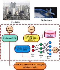
Rapid urbanization has given rise to escalating land surface temperatures, climate change, and the emergence of surface urban heat islands (SUHIs) and urban hot spots (UHSs), posing significant environmental challenges. This study, situated in the dynamic urban landscape of southern Iran, leverages Landsat satellite imagery to scrutinize the repercussions of temperature escalation on the environment. Our approach harnesses a novel Urban Thermal Field Variance Index (UTFVI) in conjunction with thermal and spectral indices to gain insights into these challenges. We employ a multifaceted methodology that integrates linear regression, cellular automata (CA)-Markov chains, and advanced neural network techniques to predict land surface temperature (LST) values and associated indicators. Over the span of 2000–2019, our findings reveal a 5% augmentation in urban heat islands (UHIs), signifying an alarming temperature increase. A striking 46% of the region, as uncovered by UTFVI, falls into the most severe categories of ecological discomfort. Our analysis underscores the robust correlations between LST and critical indices, notably the Normalized Difference Built Index (NDBI) (0.96), Normalized Difference Vegetation Index (NDVI) (-0.71), UTFVI (0.98), and SUHI (0.82). Notably, our original contributions lie in the application of Artificial Neural Networks (ANNs), wherein the Multilayer Perceptron (MLP) method excels in predicting UTFVI (R2=0.96) and NDBI (R2=0.96), while the Radial Basis Function (RBF) method demonstrates remarkable accuracy in forecasting the SUHI index (R2=0.96). These achievements signify a groundbreaking advancement in comprehending the intricate dynamics of urban environmental conditions. The repercussions of increased urbanization, the proliferation of barren land, and dwindling vegetation in 2019 manifest in a marked decline in ecological quality, with a concomitant surge in temperatures within the study area. These findings underscore the pressing need for informed urban planning and sustainable practices to mitigate the detrimental effects of urban heat islands and their impact on local climates.
期刊介绍:
Sustainable computing is a rapidly expanding research area spanning the fields of computer science and engineering, electrical engineering as well as other engineering disciplines. The aim of Sustainable Computing: Informatics and Systems (SUSCOM) is to publish the myriad research findings related to energy-aware and thermal-aware management of computing resource. Equally important is a spectrum of related research issues such as applications of computing that can have ecological and societal impacts. SUSCOM publishes original and timely research papers and survey articles in current areas of power, energy, temperature, and environment related research areas of current importance to readers. SUSCOM has an editorial board comprising prominent researchers from around the world and selects competitively evaluated peer-reviewed papers.


 分享
分享
 求助内容:
求助内容: 应助结果提醒方式:
 扫码关注我们
