{"title":"图尔基耶马尔马拉海 Bandırma 海湾海平面低位以来的地震地层学","authors":"Denizhan Vardar, Hande Aykurt Vardar","doi":"10.1007/s00367-024-00773-6","DOIUrl":null,"url":null,"abstract":"<p>Near coasts and shelves are strongly affected by the hydrodynamic forces and involves important information about the long term and permanent changes. Understanding the past dynamic transformations of shelves and near coasts can shed the future projections about effects of climate changes. High-resolution seismic and multibeam bathymetry data shed light on sedimentation since the last sea level lowstand in the Bandırma Bay, southern shelf area of the Marmara Sea. Five different seismic units were identified from the bottom upward based on seismic stratigraphic analysis, which are bounded by the reflection surfaces. Differential hydrological and depositional processes in the bay are shown by the definition and mapping of these unique seismic units and surfaces in the shallow sedimentary record: The water level in the basin crossed the threshold between the two basins, and advancing flows began from the north to the western basin. The basin continued to fill with water, and progressive depositions were interrupted with the onlaps of U3–4. The water level rose above the threshold in both basins, resulting in the two lakes becoming a single lake and the creation of marine conditions. The initial deposition in the eastern basin was fluvial, deposited in the form of regressive systems tracts. The overall morphology and stratigraphic settings observed in Bandırma Bay have nearly the same characteristics as those observed in the Sea of Marmara (like northern and western Marmara shelf, Gemlik Bay, Büyükçekmece Bay etc.) oceanography, implying that similar hydrodynamic conditions and erosional and depositional processes are controlled mainly by sea level changes controlled by climate changes related to morphological properties.</p>","PeriodicalId":12500,"journal":{"name":"Geo-Marine Letters","volume":"79 1","pages":""},"PeriodicalIF":1.4000,"publicationDate":"2024-06-17","publicationTypes":"Journal Article","fieldsOfStudy":null,"isOpenAccess":false,"openAccessPdf":"","citationCount":"0","resultStr":"{\"title\":\"Seismic stratigraphy of the Bandırma Bay since sea-level lowstand, Sea of Marmara, Türkiye\",\"authors\":\"Denizhan Vardar, Hande Aykurt Vardar\",\"doi\":\"10.1007/s00367-024-00773-6\",\"DOIUrl\":null,\"url\":null,\"abstract\":\"<p>Near coasts and shelves are strongly affected by the hydrodynamic forces and involves important information about the long term and permanent changes. Understanding the past dynamic transformations of shelves and near coasts can shed the future projections about effects of climate changes. High-resolution seismic and multibeam bathymetry data shed light on sedimentation since the last sea level lowstand in the Bandırma Bay, southern shelf area of the Marmara Sea. Five different seismic units were identified from the bottom upward based on seismic stratigraphic analysis, which are bounded by the reflection surfaces. Differential hydrological and depositional processes in the bay are shown by the definition and mapping of these unique seismic units and surfaces in the shallow sedimentary record: The water level in the basin crossed the threshold between the two basins, and advancing flows began from the north to the western basin. The basin continued to fill with water, and progressive depositions were interrupted with the onlaps of U3–4. The water level rose above the threshold in both basins, resulting in the two lakes becoming a single lake and the creation of marine conditions. The initial deposition in the eastern basin was fluvial, deposited in the form of regressive systems tracts. The overall morphology and stratigraphic settings observed in Bandırma Bay have nearly the same characteristics as those observed in the Sea of Marmara (like northern and western Marmara shelf, Gemlik Bay, Büyükçekmece Bay etc.) oceanography, implying that similar hydrodynamic conditions and erosional and depositional processes are controlled mainly by sea level changes controlled by climate changes related to morphological properties.</p>\",\"PeriodicalId\":12500,\"journal\":{\"name\":\"Geo-Marine Letters\",\"volume\":\"79 1\",\"pages\":\"\"},\"PeriodicalIF\":1.4000,\"publicationDate\":\"2024-06-17\",\"publicationTypes\":\"Journal Article\",\"fieldsOfStudy\":null,\"isOpenAccess\":false,\"openAccessPdf\":\"\",\"citationCount\":\"0\",\"resultStr\":null,\"platform\":\"Semanticscholar\",\"paperid\":null,\"PeriodicalName\":\"Geo-Marine Letters\",\"FirstCategoryId\":\"89\",\"ListUrlMain\":\"https://doi.org/10.1007/s00367-024-00773-6\",\"RegionNum\":4,\"RegionCategory\":\"地球科学\",\"ArticlePicture\":[],\"TitleCN\":null,\"AbstractTextCN\":null,\"PMCID\":null,\"EPubDate\":\"\",\"PubModel\":\"\",\"JCR\":\"Q3\",\"JCRName\":\"GEOSCIENCES, MULTIDISCIPLINARY\",\"Score\":null,\"Total\":0}","platform":"Semanticscholar","paperid":null,"PeriodicalName":"Geo-Marine Letters","FirstCategoryId":"89","ListUrlMain":"https://doi.org/10.1007/s00367-024-00773-6","RegionNum":4,"RegionCategory":"地球科学","ArticlePicture":[],"TitleCN":null,"AbstractTextCN":null,"PMCID":null,"EPubDate":"","PubModel":"","JCR":"Q3","JCRName":"GEOSCIENCES, MULTIDISCIPLINARY","Score":null,"Total":0}
Seismic stratigraphy of the Bandırma Bay since sea-level lowstand, Sea of Marmara, Türkiye
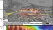
Near coasts and shelves are strongly affected by the hydrodynamic forces and involves important information about the long term and permanent changes. Understanding the past dynamic transformations of shelves and near coasts can shed the future projections about effects of climate changes. High-resolution seismic and multibeam bathymetry data shed light on sedimentation since the last sea level lowstand in the Bandırma Bay, southern shelf area of the Marmara Sea. Five different seismic units were identified from the bottom upward based on seismic stratigraphic analysis, which are bounded by the reflection surfaces. Differential hydrological and depositional processes in the bay are shown by the definition and mapping of these unique seismic units and surfaces in the shallow sedimentary record: The water level in the basin crossed the threshold between the two basins, and advancing flows began from the north to the western basin. The basin continued to fill with water, and progressive depositions were interrupted with the onlaps of U3–4. The water level rose above the threshold in both basins, resulting in the two lakes becoming a single lake and the creation of marine conditions. The initial deposition in the eastern basin was fluvial, deposited in the form of regressive systems tracts. The overall morphology and stratigraphic settings observed in Bandırma Bay have nearly the same characteristics as those observed in the Sea of Marmara (like northern and western Marmara shelf, Gemlik Bay, Büyükçekmece Bay etc.) oceanography, implying that similar hydrodynamic conditions and erosional and depositional processes are controlled mainly by sea level changes controlled by climate changes related to morphological properties.
期刊介绍:
Geo-Marine Letters is an international peer-reviewed journal focussing on the rapid publication of concise original studies and reviews dealing with processes, products and techniques in marine geology, geophysics, and geochemistry. Coverage spans
- structural geology, including plate tectonics of recent active and passive margins
- sea-bed morphology, physiography and morphodynamics
- sediment transport, depositional processes and sedimentary facies analysis
- stratigraphy, basin analysis and paleoenvironmental reconstruction
- sea-level history, paleoproductivity, gas hydrates, salt domes and brines
- sediment-water interaction and organism-sediment relationships
- geochemical tracers, stable isotopes and authigenic mineral formation
- geotechnical properties and application of new geo-marine techniques, and more.
In addition to regular articles, reviews, discussion/reply articles and technical papers, Geo-Marine Letters welcomes contributions by guest editors in the form of conference/workshop proceedings, or bundles of papers dealing with specific themes.


 分享
分享
 求助内容:
求助内容: 应助结果提醒方式:
 扫码关注我们
