{"title":"一般的高水位一般在堤岸吗?将证据权重法应用于河流圈定","authors":"Gabrielle C. L. David, Daniel Hamill","doi":"10.1111/1752-1688.13226","DOIUrl":null,"url":null,"abstract":"<p>The ordinary high water mark (OHWM) is a regulatory boundary essential to identifying the lateral jurisdictional limits of rivers and streams in the United States (U.S.). Bankfull is a scientific concept that has been defined and identified in a multitude of ways by scientists. Geomorphologist and hydrologist have long recognized that there can be variability in the identification of bankfull depending on how bankfull is defined. Furthermore, this variability is only increased by the inherent variability in stream characteristics that occurs along a reach of channel. Because of the overlap in the regulatory definition of OHWM and the scientific definitions of bankfull, one of the primary purposes of the study is to apply the definition of OHWM and compare it to bankfull in a variety of channel types in different climatic, hydrologic, and geologic settings. Our results show that there is a clear overlap between the identification of the OHWM and bankfull elevations. Regulatory practitioners are generally not specialized in fluvial geomorphology and yet are tasked with consistently and accurately identifying the OHWM in a variety of stream types throughout the U.S. Therefore, we also present how to apply a weight-of-evidence approach through a clear step-by-step process to potentially improve consistency and accuracy in identification of OHWM and bankfull by both scientists and non-scientists.</p>","PeriodicalId":17234,"journal":{"name":"Journal of The American Water Resources Association","volume":"60 6","pages":"1029-1057"},"PeriodicalIF":2.2000,"publicationDate":"2024-08-06","publicationTypes":"Journal Article","fieldsOfStudy":null,"isOpenAccess":false,"openAccessPdf":"https://onlinelibrary.wiley.com/doi/epdf/10.1111/1752-1688.13226","citationCount":"0","resultStr":"{\"title\":\"Is the ordinary high water mark ordinarily at bankfull? Applying a weight-of-evidence approach to stream delineation\",\"authors\":\"Gabrielle C. L. David, Daniel Hamill\",\"doi\":\"10.1111/1752-1688.13226\",\"DOIUrl\":null,\"url\":null,\"abstract\":\"<p>The ordinary high water mark (OHWM) is a regulatory boundary essential to identifying the lateral jurisdictional limits of rivers and streams in the United States (U.S.). Bankfull is a scientific concept that has been defined and identified in a multitude of ways by scientists. Geomorphologist and hydrologist have long recognized that there can be variability in the identification of bankfull depending on how bankfull is defined. Furthermore, this variability is only increased by the inherent variability in stream characteristics that occurs along a reach of channel. Because of the overlap in the regulatory definition of OHWM and the scientific definitions of bankfull, one of the primary purposes of the study is to apply the definition of OHWM and compare it to bankfull in a variety of channel types in different climatic, hydrologic, and geologic settings. Our results show that there is a clear overlap between the identification of the OHWM and bankfull elevations. Regulatory practitioners are generally not specialized in fluvial geomorphology and yet are tasked with consistently and accurately identifying the OHWM in a variety of stream types throughout the U.S. Therefore, we also present how to apply a weight-of-evidence approach through a clear step-by-step process to potentially improve consistency and accuracy in identification of OHWM and bankfull by both scientists and non-scientists.</p>\",\"PeriodicalId\":17234,\"journal\":{\"name\":\"Journal of The American Water Resources Association\",\"volume\":\"60 6\",\"pages\":\"1029-1057\"},\"PeriodicalIF\":2.2000,\"publicationDate\":\"2024-08-06\",\"publicationTypes\":\"Journal Article\",\"fieldsOfStudy\":null,\"isOpenAccess\":false,\"openAccessPdf\":\"https://onlinelibrary.wiley.com/doi/epdf/10.1111/1752-1688.13226\",\"citationCount\":\"0\",\"resultStr\":null,\"platform\":\"Semanticscholar\",\"paperid\":null,\"PeriodicalName\":\"Journal of The American Water Resources Association\",\"FirstCategoryId\":\"93\",\"ListUrlMain\":\"https://onlinelibrary.wiley.com/doi/10.1111/1752-1688.13226\",\"RegionNum\":4,\"RegionCategory\":\"环境科学与生态学\",\"ArticlePicture\":[],\"TitleCN\":null,\"AbstractTextCN\":null,\"PMCID\":null,\"EPubDate\":\"\",\"PubModel\":\"\",\"JCR\":\"Q3\",\"JCRName\":\"ENGINEERING, ENVIRONMENTAL\",\"Score\":null,\"Total\":0}","platform":"Semanticscholar","paperid":null,"PeriodicalName":"Journal of The American Water Resources Association","FirstCategoryId":"93","ListUrlMain":"https://onlinelibrary.wiley.com/doi/10.1111/1752-1688.13226","RegionNum":4,"RegionCategory":"环境科学与生态学","ArticlePicture":[],"TitleCN":null,"AbstractTextCN":null,"PMCID":null,"EPubDate":"","PubModel":"","JCR":"Q3","JCRName":"ENGINEERING, ENVIRONMENTAL","Score":null,"Total":0}
Is the ordinary high water mark ordinarily at bankfull? Applying a weight-of-evidence approach to stream delineation
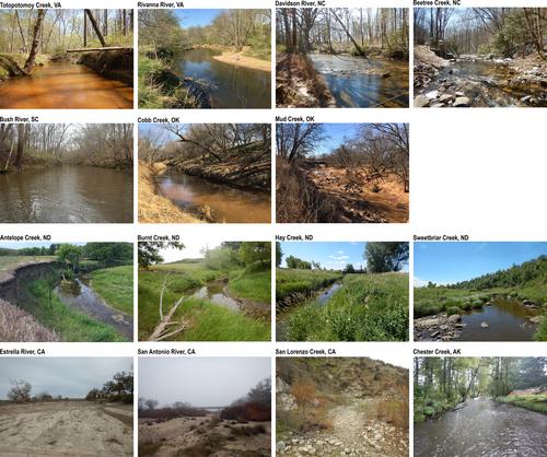
The ordinary high water mark (OHWM) is a regulatory boundary essential to identifying the lateral jurisdictional limits of rivers and streams in the United States (U.S.). Bankfull is a scientific concept that has been defined and identified in a multitude of ways by scientists. Geomorphologist and hydrologist have long recognized that there can be variability in the identification of bankfull depending on how bankfull is defined. Furthermore, this variability is only increased by the inherent variability in stream characteristics that occurs along a reach of channel. Because of the overlap in the regulatory definition of OHWM and the scientific definitions of bankfull, one of the primary purposes of the study is to apply the definition of OHWM and compare it to bankfull in a variety of channel types in different climatic, hydrologic, and geologic settings. Our results show that there is a clear overlap between the identification of the OHWM and bankfull elevations. Regulatory practitioners are generally not specialized in fluvial geomorphology and yet are tasked with consistently and accurately identifying the OHWM in a variety of stream types throughout the U.S. Therefore, we also present how to apply a weight-of-evidence approach through a clear step-by-step process to potentially improve consistency and accuracy in identification of OHWM and bankfull by both scientists and non-scientists.
期刊介绍:
JAWRA seeks to be the preeminent scholarly publication on multidisciplinary water resources issues. JAWRA papers present ideas derived from multiple disciplines woven together to give insight into a critical water issue, or are based primarily upon a single discipline with important applications to other disciplines. Papers often cover the topics of recent AWRA conferences such as riparian ecology, geographic information systems, adaptive management, and water policy.
JAWRA authors present work within their disciplinary fields to a broader audience. Our Associate Editors and reviewers reflect this diversity to ensure a knowledgeable and fair review of a broad range of topics. We particularly encourage submissions of papers which impart a ''take home message'' our readers can use.


 分享
分享
 求助内容:
求助内容: 应助结果提醒方式:
 扫码关注我们
