Alexander T. Michalek, Felipe Quintero, Gabriele Villarini
{"title":"使用山坡链接模型TETIS的美国相邻水文模拟","authors":"Alexander T. Michalek, Felipe Quintero, Gabriele Villarini","doi":"10.1111/1752-1688.13227","DOIUrl":null,"url":null,"abstract":"<p>Large-scale hydrologic modeling is important for understanding changes in water resources and flood hazard across a broad range of climatic and hydrologic conditions. Parsimonious models, although simple, allow for an efficient way to model river systems across multiple decades to even centuries. Therefore, this study aims to assess the ability of the distributed Hillslope Link Model (HLM) TETIS to simulate streamflow observations across the contiguous United States (CONUS) from 1981 to 2020. To obtain model parameters across this domain, we partition the study area into 234 HydroSHEDS level 5 basins and calibrate the model to a single representative location near the outlet of each basin using dynamical dimension search for 100 realizations. Performance is then assessed at 5046 US Geological Survey streamgages with respect to the Kling Gupta Efficiency (KGE) and bias. Our simulations result in a median KGE of 0.43, with 89% of the sites having a value above the reference of 1 − √2 (~ -0.41). Furthermore, there is a dependence of the model performance on climate regions, with the model performing better in basins in cold and temperate regions than in arid ones. While the parameters are estimated based on daily precipitation inputs, it is shown that the model performs well even when forced with hourly precipitation, highlighting the robustness of the selected parameters to different inputs. Finally, the soil related parameters show dependence on soil properties, providing a basis for future model improvement. Overall, this study highlights the model's flexibility in performing across a vast domain with different runoff generation mechanisms.</p>","PeriodicalId":17234,"journal":{"name":"Journal of The American Water Resources Association","volume":"60 6","pages":"1058-1079"},"PeriodicalIF":2.2000,"publicationDate":"2024-08-11","publicationTypes":"Journal Article","fieldsOfStudy":null,"isOpenAccess":false,"openAccessPdf":"https://onlinelibrary.wiley.com/doi/epdf/10.1111/1752-1688.13227","citationCount":"0","resultStr":"{\"title\":\"Contiguous United States hydrologic modeling using the Hillslope Link Model TETIS\",\"authors\":\"Alexander T. Michalek, Felipe Quintero, Gabriele Villarini\",\"doi\":\"10.1111/1752-1688.13227\",\"DOIUrl\":null,\"url\":null,\"abstract\":\"<p>Large-scale hydrologic modeling is important for understanding changes in water resources and flood hazard across a broad range of climatic and hydrologic conditions. Parsimonious models, although simple, allow for an efficient way to model river systems across multiple decades to even centuries. Therefore, this study aims to assess the ability of the distributed Hillslope Link Model (HLM) TETIS to simulate streamflow observations across the contiguous United States (CONUS) from 1981 to 2020. To obtain model parameters across this domain, we partition the study area into 234 HydroSHEDS level 5 basins and calibrate the model to a single representative location near the outlet of each basin using dynamical dimension search for 100 realizations. Performance is then assessed at 5046 US Geological Survey streamgages with respect to the Kling Gupta Efficiency (KGE) and bias. Our simulations result in a median KGE of 0.43, with 89% of the sites having a value above the reference of 1 − √2 (~ -0.41). Furthermore, there is a dependence of the model performance on climate regions, with the model performing better in basins in cold and temperate regions than in arid ones. While the parameters are estimated based on daily precipitation inputs, it is shown that the model performs well even when forced with hourly precipitation, highlighting the robustness of the selected parameters to different inputs. Finally, the soil related parameters show dependence on soil properties, providing a basis for future model improvement. Overall, this study highlights the model's flexibility in performing across a vast domain with different runoff generation mechanisms.</p>\",\"PeriodicalId\":17234,\"journal\":{\"name\":\"Journal of The American Water Resources Association\",\"volume\":\"60 6\",\"pages\":\"1058-1079\"},\"PeriodicalIF\":2.2000,\"publicationDate\":\"2024-08-11\",\"publicationTypes\":\"Journal Article\",\"fieldsOfStudy\":null,\"isOpenAccess\":false,\"openAccessPdf\":\"https://onlinelibrary.wiley.com/doi/epdf/10.1111/1752-1688.13227\",\"citationCount\":\"0\",\"resultStr\":null,\"platform\":\"Semanticscholar\",\"paperid\":null,\"PeriodicalName\":\"Journal of The American Water Resources Association\",\"FirstCategoryId\":\"93\",\"ListUrlMain\":\"https://onlinelibrary.wiley.com/doi/10.1111/1752-1688.13227\",\"RegionNum\":4,\"RegionCategory\":\"环境科学与生态学\",\"ArticlePicture\":[],\"TitleCN\":null,\"AbstractTextCN\":null,\"PMCID\":null,\"EPubDate\":\"\",\"PubModel\":\"\",\"JCR\":\"Q3\",\"JCRName\":\"ENGINEERING, ENVIRONMENTAL\",\"Score\":null,\"Total\":0}","platform":"Semanticscholar","paperid":null,"PeriodicalName":"Journal of The American Water Resources Association","FirstCategoryId":"93","ListUrlMain":"https://onlinelibrary.wiley.com/doi/10.1111/1752-1688.13227","RegionNum":4,"RegionCategory":"环境科学与生态学","ArticlePicture":[],"TitleCN":null,"AbstractTextCN":null,"PMCID":null,"EPubDate":"","PubModel":"","JCR":"Q3","JCRName":"ENGINEERING, ENVIRONMENTAL","Score":null,"Total":0}
引用次数: 0
摘要
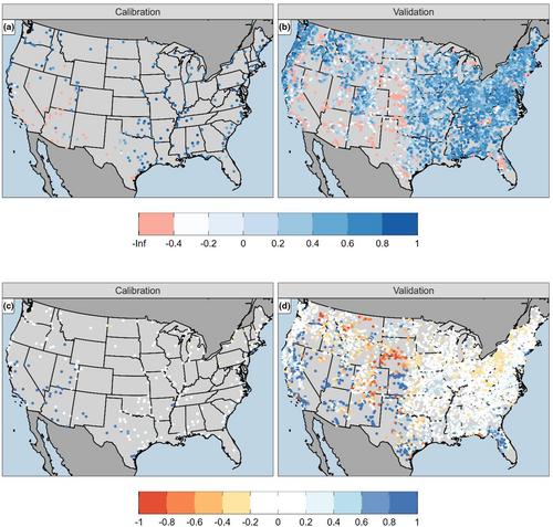
大尺度水文模拟对于理解各种气候和水文条件下水资源和洪水灾害的变化具有重要意义。简约的模型虽然简单,但却能有效地模拟几十年甚至几个世纪的河流系统。因此,本研究旨在评估分布式Hillslope Link Model (HLM) TETIS模拟1981 - 2020年美国相邻地区(CONUS)径流观测的能力。为了获得跨域的模型参数,我们将研究区域划分为234个5级流域,并使用100个实现的动态维数搜索将模型校准到每个流域出口附近的单个代表性位置。然后根据5046条美国地质调查局的流量表对克林古普塔效率(KGE)和偏差进行评估。我们的模拟结果中位数KGE为0.43,其中89%的站点的值高于参考值1−√2(~ -0.41)。此外,模型的模拟效果也与气候区域有关,在寒温带盆地的模拟效果较好,在干旱盆地的模拟效果较好。虽然参数是基于日降水输入估计的,但结果表明,即使在逐时降水的强迫下,模型也表现良好,突出了所选参数对不同输入的鲁棒性。最后,土壤相关参数表现出对土壤性质的依赖性,为进一步改进模型提供了依据。总的来说,这项研究强调了该模型在具有不同径流生成机制的广阔领域中的灵活性。
Contiguous United States hydrologic modeling using the Hillslope Link Model TETIS
Large-scale hydrologic modeling is important for understanding changes in water resources and flood hazard across a broad range of climatic and hydrologic conditions. Parsimonious models, although simple, allow for an efficient way to model river systems across multiple decades to even centuries. Therefore, this study aims to assess the ability of the distributed Hillslope Link Model (HLM) TETIS to simulate streamflow observations across the contiguous United States (CONUS) from 1981 to 2020. To obtain model parameters across this domain, we partition the study area into 234 HydroSHEDS level 5 basins and calibrate the model to a single representative location near the outlet of each basin using dynamical dimension search for 100 realizations. Performance is then assessed at 5046 US Geological Survey streamgages with respect to the Kling Gupta Efficiency (KGE) and bias. Our simulations result in a median KGE of 0.43, with 89% of the sites having a value above the reference of 1 − √2 (~ -0.41). Furthermore, there is a dependence of the model performance on climate regions, with the model performing better in basins in cold and temperate regions than in arid ones. While the parameters are estimated based on daily precipitation inputs, it is shown that the model performs well even when forced with hourly precipitation, highlighting the robustness of the selected parameters to different inputs. Finally, the soil related parameters show dependence on soil properties, providing a basis for future model improvement. Overall, this study highlights the model's flexibility in performing across a vast domain with different runoff generation mechanisms.
期刊介绍:
JAWRA seeks to be the preeminent scholarly publication on multidisciplinary water resources issues. JAWRA papers present ideas derived from multiple disciplines woven together to give insight into a critical water issue, or are based primarily upon a single discipline with important applications to other disciplines. Papers often cover the topics of recent AWRA conferences such as riparian ecology, geographic information systems, adaptive management, and water policy.
JAWRA authors present work within their disciplinary fields to a broader audience. Our Associate Editors and reviewers reflect this diversity to ensure a knowledgeable and fair review of a broad range of topics. We particularly encourage submissions of papers which impart a ''take home message'' our readers can use.


 分享
分享
 求助内容:
求助内容: 应助结果提醒方式:
 扫码关注我们
