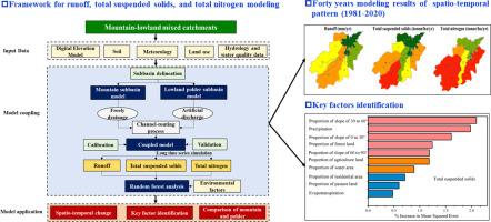
A novel framework for tracking hydrological processes and identifying key factors in mountain-lowland mixed catchments: Implications of forty years of modeling for water management
{"title":"A novel framework for tracking hydrological processes and identifying key factors in mountain-lowland mixed catchments: Implications of forty years of modeling for water management","authors":"Renhua Yan , Lingling Li , Junfeng Gao","doi":"10.1016/j.watres.2025.123424","DOIUrl":null,"url":null,"abstract":"<div><div>Quantitative analysis of runoff, total suspended solids, and total nitrogen dynamics, along with the identification of key factors within catchments, is essential for accurately addressing issues related to turbid and polluted water. Nevertheless, their implementation encounters significant challenges when applied to a mixed catchment containing mountain areas and lowland polder regions, due to the highly heterogeneous hydrological behaviors and consequently the lack of an appropriate approach. Faced with this problem, this study developed a framework by coupling the Soil and Water Assessment Tool (SWAT) and improved Polder Hydrology and Nitrogen modelling System (PHNS), and Random Forest analysis method to track the spatio-temporal changes in runoff, total suspended solids, and total nitrogen loading and identify their environmental determinants in a representative mountain-lowland mixed catchment, southeastern China. The coupled model performed very well for runoff (R<sup>2</sup>≥0.90) and water quality variables (total suspended solids: R<sup>2</sup>≥0.88; total nitrogen: R<sup>2</sup>≥0.73) in both the calibration and validation periods, and showed improvements compared with standalone SWAT model. Forty years’ modelling results indicated that the upstream subbasins 15 (32.86 tonnes/ha/yr), 14 (33.96 tonnes/ha/yr), and 11 (32.32 tonnes/ha/yr) were the critical source areas for total suspended solids and total nitrogen. However, the downstream polder subbasins functioned as a sink for runoff, total suspended solids, and total nitrogen, exporting lower loading intensities. Precipitation and the proportion of slope of 0 to 30° were identified as the critical factors influencing runoff, total suspended solids, and total nitrogen. The proportion of water area also significantly, negatively influenced runoff and total suspended solids. This study provided a feasible method to investigate runoff, total suspended solids, and total nitrogen processes and their environmental factors’ impact, and thus identifying the critical source areas and targeted measures to control the non-point source pollution of mountain-lowland mixed catchments.</div></div>","PeriodicalId":443,"journal":{"name":"Water Research","volume":"279 ","pages":"Article 123424"},"PeriodicalIF":12.4000,"publicationDate":"2025-07-01","publicationTypes":"Journal Article","fieldsOfStudy":null,"isOpenAccess":false,"openAccessPdf":"","citationCount":"0","resultStr":null,"platform":"Semanticscholar","paperid":null,"PeriodicalName":"Water Research","FirstCategoryId":"93","ListUrlMain":"https://www.sciencedirect.com/science/article/pii/S0043135425003379","RegionNum":1,"RegionCategory":"环境科学与生态学","ArticlePicture":[],"TitleCN":null,"AbstractTextCN":null,"PMCID":null,"EPubDate":"2025/3/7 0:00:00","PubModel":"Epub","JCR":"Q1","JCRName":"ENGINEERING, ENVIRONMENTAL","Score":null,"Total":0}
引用次数: 0
Abstract
Quantitative analysis of runoff, total suspended solids, and total nitrogen dynamics, along with the identification of key factors within catchments, is essential for accurately addressing issues related to turbid and polluted water. Nevertheless, their implementation encounters significant challenges when applied to a mixed catchment containing mountain areas and lowland polder regions, due to the highly heterogeneous hydrological behaviors and consequently the lack of an appropriate approach. Faced with this problem, this study developed a framework by coupling the Soil and Water Assessment Tool (SWAT) and improved Polder Hydrology and Nitrogen modelling System (PHNS), and Random Forest analysis method to track the spatio-temporal changes in runoff, total suspended solids, and total nitrogen loading and identify their environmental determinants in a representative mountain-lowland mixed catchment, southeastern China. The coupled model performed very well for runoff (R2≥0.90) and water quality variables (total suspended solids: R2≥0.88; total nitrogen: R2≥0.73) in both the calibration and validation periods, and showed improvements compared with standalone SWAT model. Forty years’ modelling results indicated that the upstream subbasins 15 (32.86 tonnes/ha/yr), 14 (33.96 tonnes/ha/yr), and 11 (32.32 tonnes/ha/yr) were the critical source areas for total suspended solids and total nitrogen. However, the downstream polder subbasins functioned as a sink for runoff, total suspended solids, and total nitrogen, exporting lower loading intensities. Precipitation and the proportion of slope of 0 to 30° were identified as the critical factors influencing runoff, total suspended solids, and total nitrogen. The proportion of water area also significantly, negatively influenced runoff and total suspended solids. This study provided a feasible method to investigate runoff, total suspended solids, and total nitrogen processes and their environmental factors’ impact, and thus identifying the critical source areas and targeted measures to control the non-point source pollution of mountain-lowland mixed catchments.
径流、总悬浮固体和总氮动力学的定量分析,以及流域内关键因素的识别,对于准确解决与浑浊和污染水相关的问题至关重要。然而,由于水文行为高度不均匀,因此缺乏适当的方法,在山区和低地圩区混合集水区实施这些方法时遇到了重大挑战。针对这一问题,本研究建立了一个基于SWAT和改进的圩田水文氮模拟系统(PHNS)的耦合框架,结合随机森林分析方法,对中国东南部具有代表性的山地-低地混合流域径流、总悬浮物和总氮负荷的时空变化进行了追踪,并确定了它们的环境决定因素。耦合模型对径流(R2≥0.90)和水质变量(总悬浮物:R2≥0.88;总氮:R2≥0.73),与独立SWAT模型相比均有改善。40年模拟结果表明,上游子流域15 (32.86 t /ha/yr)、14 (33.96 t /ha/yr)和11 (32.32 t /ha/yr)是总悬浮物和总氮的关键源区。然而,下游圩子流域作为径流、总悬浮固体和总氮的汇,输出较低的负荷强度。降水量和0 ~ 30°坡度比例是影响径流、总悬浮物和总氮的关键因素。水体面积比例对径流和总悬浮物也有显著的负面影响。本研究为研究山低地混合流域径流、总悬浮物和总氮过程及其环境因子的影响提供了一种可行的方法,从而确定关键源区和有针对性地控制非点源污染的措施。
期刊介绍:
Water Research, along with its open access companion journal Water Research X, serves as a platform for publishing original research papers covering various aspects of the science and technology related to the anthropogenic water cycle, water quality, and its management worldwide. The audience targeted by the journal comprises biologists, chemical engineers, chemists, civil engineers, environmental engineers, limnologists, and microbiologists. The scope of the journal include:
•Treatment processes for water and wastewaters (municipal, agricultural, industrial, and on-site treatment), including resource recovery and residuals management;
•Urban hydrology including sewer systems, stormwater management, and green infrastructure;
•Drinking water treatment and distribution;
•Potable and non-potable water reuse;
•Sanitation, public health, and risk assessment;
•Anaerobic digestion, solid and hazardous waste management, including source characterization and the effects and control of leachates and gaseous emissions;
•Contaminants (chemical, microbial, anthropogenic particles such as nanoparticles or microplastics) and related water quality sensing, monitoring, fate, and assessment;
•Anthropogenic impacts on inland, tidal, coastal and urban waters, focusing on surface and ground waters, and point and non-point sources of pollution;
•Environmental restoration, linked to surface water, groundwater and groundwater remediation;
•Analysis of the interfaces between sediments and water, and between water and atmosphere, focusing specifically on anthropogenic impacts;
•Mathematical modelling, systems analysis, machine learning, and beneficial use of big data related to the anthropogenic water cycle;
•Socio-economic, policy, and regulations studies.


 分享
分享
 求助内容:
求助内容: 应助结果提醒方式:
 扫码关注我们
