{"title":"通过参数重采样从航空激光雷达点云到多尺度城市表示水平","authors":"Chiara Romanengo, Bianca Falcidieno, Silvia Biasotti","doi":"10.1016/j.cag.2024.104022","DOIUrl":null,"url":null,"abstract":"<div><p>Urban simulations that involve disaster prevention, urban design, and assisted navigation heavily rely on urban geometric models. While large urban areas need a lot of time to be acquired terrestrially, government organizations have already conducted massive aerial LiDAR surveys, some even at the national level. This work aims to provide a pipeline for extracting multi-scale point clouds from 2D building footprints and airborne LiDAR data, which depends on whether the points represent buildings, vegetation, or ground. We denoise the roof slopes, match the vegetation, and roughly recreate the building façades frequently hidden to aerial acquisition using a parametric representation of geometric primitives. We then carry out multiple-scale samplings of the urban geometry until a 3D urban representation can be achieved because we annotate the new version of the original point cloud with the parametric equations representing each part. We mainly tested our methodology in a real-world setting – the city of Genoa – which includes historical buildings and is heavily characterized by irregular ground slopes. Moreover, we present the results of urban reconstruction on part of two other cities, Matera, which has a complex morphology like Genoa, and Rotterdam.</p></div>","PeriodicalId":50628,"journal":{"name":"Computers & Graphics-Uk","volume":"123 ","pages":"Article 104022"},"PeriodicalIF":2.8000,"publicationDate":"2024-10-01","publicationTypes":"Journal Article","fieldsOfStudy":null,"isOpenAccess":false,"openAccessPdf":"https://www.sciencedirect.com/science/article/pii/S0097849324001572/pdfft?md5=a617708d0acaf24ecd321d09a5821721&pid=1-s2.0-S0097849324001572-main.pdf","citationCount":"0","resultStr":"{\"title\":\"From aerial LiDAR point clouds to multiscale urban representation levels by a parametric resampling\",\"authors\":\"Chiara Romanengo, Bianca Falcidieno, Silvia Biasotti\",\"doi\":\"10.1016/j.cag.2024.104022\",\"DOIUrl\":null,\"url\":null,\"abstract\":\"<div><p>Urban simulations that involve disaster prevention, urban design, and assisted navigation heavily rely on urban geometric models. While large urban areas need a lot of time to be acquired terrestrially, government organizations have already conducted massive aerial LiDAR surveys, some even at the national level. This work aims to provide a pipeline for extracting multi-scale point clouds from 2D building footprints and airborne LiDAR data, which depends on whether the points represent buildings, vegetation, or ground. We denoise the roof slopes, match the vegetation, and roughly recreate the building façades frequently hidden to aerial acquisition using a parametric representation of geometric primitives. We then carry out multiple-scale samplings of the urban geometry until a 3D urban representation can be achieved because we annotate the new version of the original point cloud with the parametric equations representing each part. We mainly tested our methodology in a real-world setting – the city of Genoa – which includes historical buildings and is heavily characterized by irregular ground slopes. Moreover, we present the results of urban reconstruction on part of two other cities, Matera, which has a complex morphology like Genoa, and Rotterdam.</p></div>\",\"PeriodicalId\":50628,\"journal\":{\"name\":\"Computers & Graphics-Uk\",\"volume\":\"123 \",\"pages\":\"Article 104022\"},\"PeriodicalIF\":2.8000,\"publicationDate\":\"2024-10-01\",\"publicationTypes\":\"Journal Article\",\"fieldsOfStudy\":null,\"isOpenAccess\":false,\"openAccessPdf\":\"https://www.sciencedirect.com/science/article/pii/S0097849324001572/pdfft?md5=a617708d0acaf24ecd321d09a5821721&pid=1-s2.0-S0097849324001572-main.pdf\",\"citationCount\":\"0\",\"resultStr\":null,\"platform\":\"Semanticscholar\",\"paperid\":null,\"PeriodicalName\":\"Computers & Graphics-Uk\",\"FirstCategoryId\":\"94\",\"ListUrlMain\":\"https://www.sciencedirect.com/science/article/pii/S0097849324001572\",\"RegionNum\":4,\"RegionCategory\":\"计算机科学\",\"ArticlePicture\":[],\"TitleCN\":null,\"AbstractTextCN\":null,\"PMCID\":null,\"EPubDate\":\"2024/7/31 0:00:00\",\"PubModel\":\"Epub\",\"JCR\":\"Q2\",\"JCRName\":\"COMPUTER SCIENCE, SOFTWARE ENGINEERING\",\"Score\":null,\"Total\":0}","platform":"Semanticscholar","paperid":null,"PeriodicalName":"Computers & Graphics-Uk","FirstCategoryId":"94","ListUrlMain":"https://www.sciencedirect.com/science/article/pii/S0097849324001572","RegionNum":4,"RegionCategory":"计算机科学","ArticlePicture":[],"TitleCN":null,"AbstractTextCN":null,"PMCID":null,"EPubDate":"2024/7/31 0:00:00","PubModel":"Epub","JCR":"Q2","JCRName":"COMPUTER SCIENCE, SOFTWARE ENGINEERING","Score":null,"Total":0}
From aerial LiDAR point clouds to multiscale urban representation levels by a parametric resampling
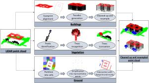
Urban simulations that involve disaster prevention, urban design, and assisted navigation heavily rely on urban geometric models. While large urban areas need a lot of time to be acquired terrestrially, government organizations have already conducted massive aerial LiDAR surveys, some even at the national level. This work aims to provide a pipeline for extracting multi-scale point clouds from 2D building footprints and airborne LiDAR data, which depends on whether the points represent buildings, vegetation, or ground. We denoise the roof slopes, match the vegetation, and roughly recreate the building façades frequently hidden to aerial acquisition using a parametric representation of geometric primitives. We then carry out multiple-scale samplings of the urban geometry until a 3D urban representation can be achieved because we annotate the new version of the original point cloud with the parametric equations representing each part. We mainly tested our methodology in a real-world setting – the city of Genoa – which includes historical buildings and is heavily characterized by irregular ground slopes. Moreover, we present the results of urban reconstruction on part of two other cities, Matera, which has a complex morphology like Genoa, and Rotterdam.
期刊介绍:
Computers & Graphics is dedicated to disseminate information on research and applications of computer graphics (CG) techniques. The journal encourages articles on:
1. Research and applications of interactive computer graphics. We are particularly interested in novel interaction techniques and applications of CG to problem domains.
2. State-of-the-art papers on late-breaking, cutting-edge research on CG.
3. Information on innovative uses of graphics principles and technologies.
4. Tutorial papers on both teaching CG principles and innovative uses of CG in education.


 分享
分享
 求助内容:
求助内容: 应助结果提醒方式:
 扫码关注我们
